
Map of the battlefield
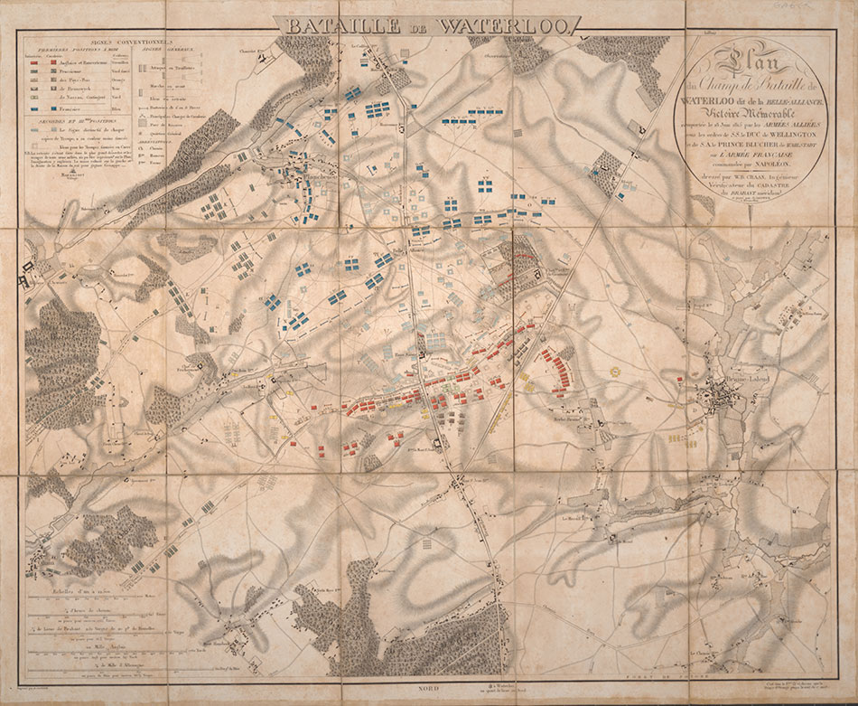 Plan du champ de Bataille de Waterloo dit la Belle-allianceThe map reproduced here was compiled a day after the battle, possibly by the publisher WB Craan, following interviews with personnel from both sides. Visible are the French forces of Napoleon in blue, the forces of the British and Dutch in red and the Prussians in dark green.
The detailed legend at the top left shows where cavalry and infantry battalions were positioned, where gun batteries were stationed and where additional Allied forces under Wellington’s command, such as those from the Netherlands, Nassau and Brunswick, were mustered.
The way the battle progressed can be traced through the lines on the map indicating the secondary positions of the bodies of troops.
 Case for the map of the Battle of Waterloo shown hereThe many lines leading to La Haye Sainte in the centre of the map and Château Hougoumont to its right indicate significant directions of the French attacks – and where their troops became bogged down under heavy resistance. Also marked are significant cavalry charges, some of which stretch deep into enemy territory.
The map is particularly useful for conveying the final throes of the battle, as it shows the Prussian forces to the east advancing on Napoleon’s right flank. At six o’clock in the evening, following a day of fighting, the Allied garrison at La Haye Sainte fell, having run out of ammunition.
Napoleon launched a further attack through the Allied centre with his Imperial Guard but again his troops were fiercely repelled by musket and bayonet wielding British forces. As the Imperial Guard retreated, the Prussians at the east side of the battlefield advanced, extinguishing any hopes of French glory and securing an Allied victory.
In this exhibition
- Napoleon
- Wellington
- The Battle of Waterloo
- Military techniques
- Map of the battlefield
- An account of the battle
- Further military techniques
- Military medicine and care of the wounded
- Treaties of peace
- Waterloo and its aftermath in the literary imagination
- From Waterloo to Peterloo: Britain 1815-20
- Select bibliography