
Imperial connections
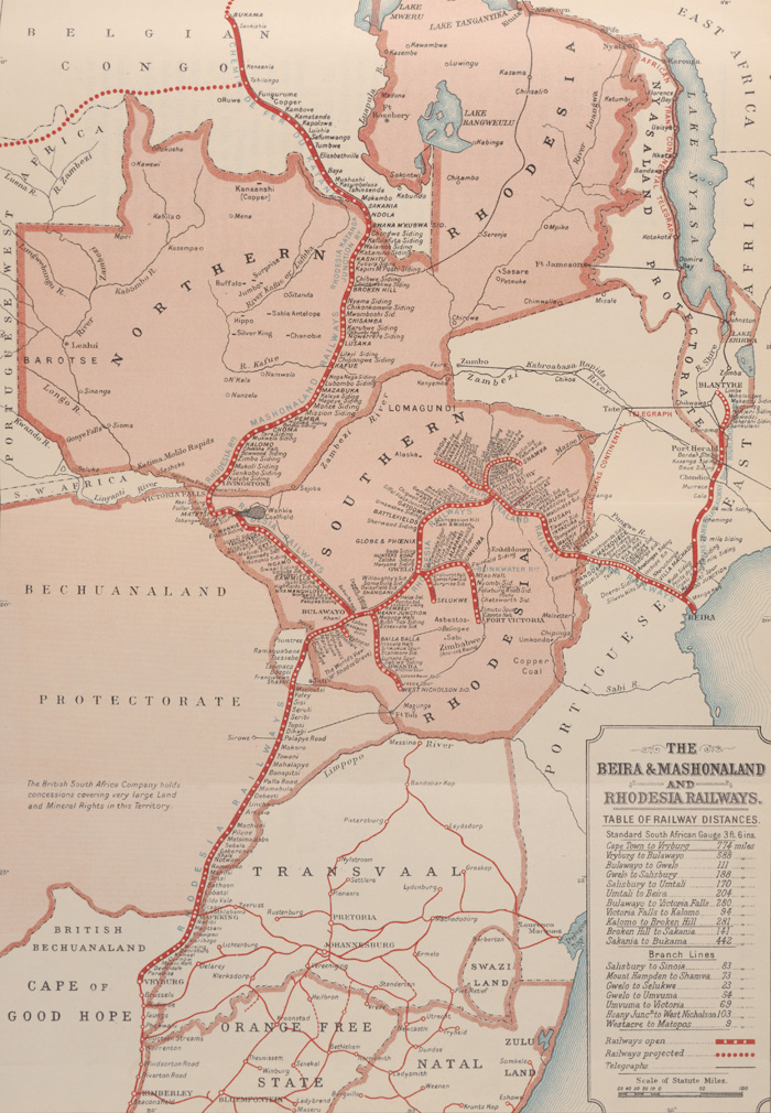 Map showing a section of the planned route at the southern end of Africa.The extraordinarily grand plan of connecting the north of Africa with the south by rail, as envisaged by the British, and notably by the imperialist Cecil Rhodes (1853-1902), was never completed, though sections of the line remain in operation today.
Such a railway would have allowed Britain to strengthen its imperial hold over large parts of the continent, at the expense of European colonial rivals, and would also have facilitated the transportation of the vast mineral resources of Africa for financial gain.
Rhodes, through the power wielded by his British South Africa Company, was able to grant concessions to speculators in search of mineral deposits and as new resources were discovered, it made economic sense for the railway to follow.
The map here shows a section of the planned route at the southern end of the continent. The map legend indicates completed sections, branches and proposed lines, as well as telegraph lines which have been laid.
This most ambitious of imperial designs is recorded in this five-volume set and a true panorama of the continent is found within its pages. There are stories of construction being held up by a man-eating pride of lions; of the capture of supposed cannibals and of railway engineers supplementing exhausted ration supplies with Nile snails, prepared à la française. Illustrations and photographs include those of the varied indigenous peoples found along the route, of European construction officials and of diverse camps and residences.
In this exhibition
- Early telegraphy
- Submarine telegraphy
- Railways and the Victorian age
- Planning the network
- Developing the engines
- Showcasing British locomotives
- Imperial connections
- Maritime innovation and control of the seas
- The pre-history of the Channel Tunnel
- Imperial designs of architecture
- A 'national disgrace': sanitation, sewage and agriculture
- Scientific and technological enquiry
- Select bibliography