
1867 plan of the Tunnel
 Cross-section of geological formations underneath the Straits of Dover.At several points in the period from 1802 to 1882 engineers and visionaries, both English and French, devised schemes of varying practicalit for constructing either tunnels or bridges across the English Channel.
Although the first recorded underwater tunnel was built in ancient Mesopotamia, it was Victorian engineers who pioneered long distance tunnelling. A compressed air boring machine, which would have made explosives obsolete and construction easier, was invented in the 1870s; the layer of impervious grey chalk underneath the Straits of Dover was conducive to construction; and the commercial advantages of a Channel Tunnel were attractive to most Victorians, for whom free trade was an unofficial religion.
However, in 1882, just at the time when a considerable length of tunnel had been built on both shores, the project ceased. The army and the navy both objected that the Tunnel would increase the likelihood of an invasion, and would thus compel Britain to have a standing army. This would alter British society and the way in which Britain projected its power overseas. These anxieties proved decisive.
In addition, the deterioration in relations between Britain and France following Britain’s tightening grip over the Suez Canal and Egypt from the early 1880s put paid to further progress. By the time of the entente cordiale in 1904, Germany had replaced France as Britain’s likely military opponent, but the fears of invasion remained.
Joseph-Aimé Thomé de Gamond (1807-75) was a French polymath who had obtained doctorates in both medicine and law and was a military engineer and geologist. He was educated to a standard which far exceeded the auto-didacticism of many British engineers of that period.
Unlike the other Channel Tunnel dreamers, he undertook detailed geological investigations and hazarded precise forecasts of economic benefits. His medical knowledge must have been useful when he undertook the extraordinary feat of diving to bring up geological samples. Apart from wearing ten pigs’ bladders for buoyancy and having 160 pounds of stones for ballast tied round his waist, he was naked. Having filled his mouth with olive oil so that (apparently) he could expel air without water being forced into his lungs, he managed to reach a depth of 100 feet.
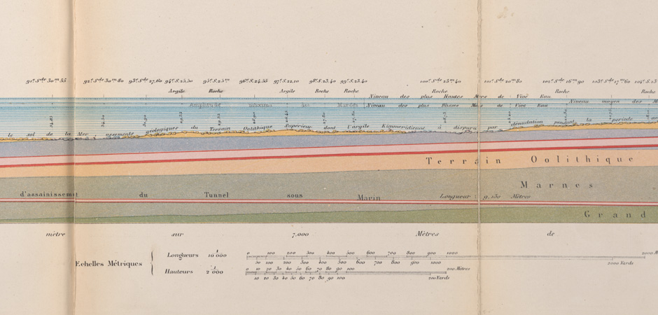
 Transverse section of the Tunnel and approach cuttings.Through his investigations he established that the impervious grey chalk stratum under the Channel was continuous, and that therefore geology would not prevent the Tunnel from being built. The result of his painstaking investigations is shown in the illustration above.
Although the plan went through several incarnations, the final elaboration was published in 1857, with modifications for the Exposition Universelle in Paris in 1867. That plan is shown here. The envisaged route ran from Eastwear Bay, east of Folkestone, to Cap Grisnez, a distance of approximately 21 miles.
The plan included a proposal to make 13 islands in the Channel, and to begin the Tunnel at these points by sinking shafts in them. The Tunnel would be stone-vaulted, and would measure internally seven metres high and nine metres wide.
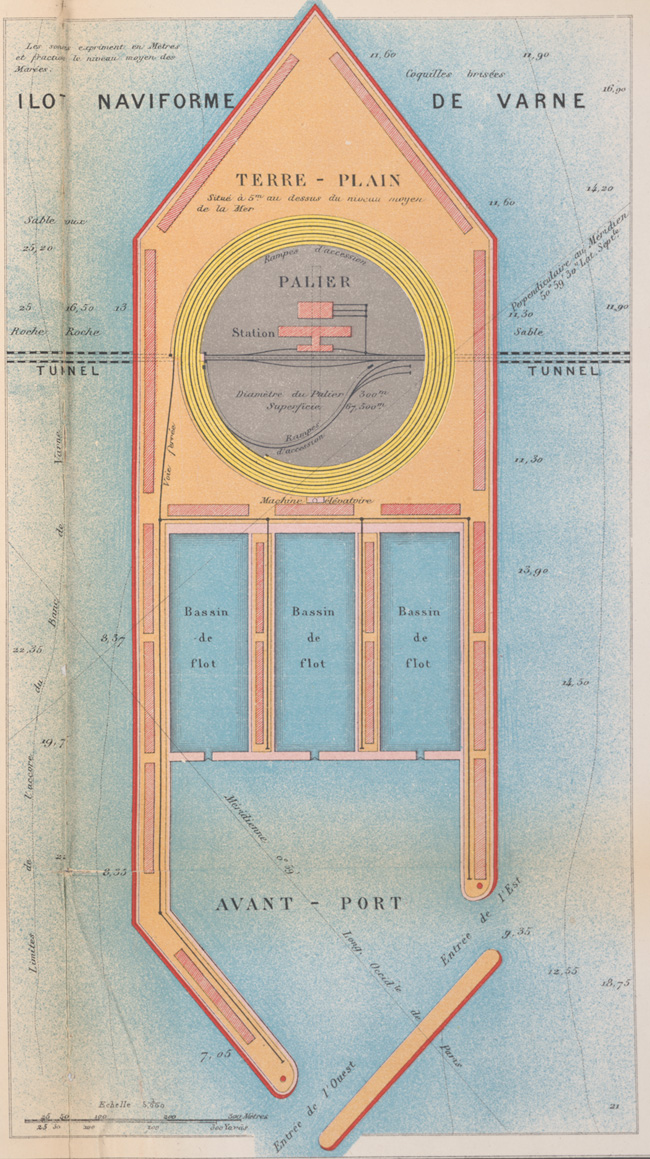 Plan of the international harbour at Varne Bank.The lower part would carry a double railway track, with narrow footways on either side. A drainage duct would run underneath the tracks. There would be three ventilation shafts, one at either end and one on the Varne Bank, which was envisaged to be a major entrepot for goods for and from trains and ships. Gamond tried to deal with military objections by planning to install valves which would flood the Tunnel in case of invasion.
The illustration above right shows a transverse section of the Tunnel and approach cuttings as envisaged by Gamond.
On the left is a plan of the international harbour at Varne Bank, showing rail tracks spiralling up from the tunnel. There would have been a huge shaft, measuring 300 metres across and descending to the level of the tunnel, 45 metres under the sea.
In this exhibition
- Early telegraphy
- Submarine telegraphy
- Railways and the Victorian age
- Maritime innovation and control of the seas
- The pre-history of the Channel Tunnel
- 1867 plan of the Tunnel
- Imperial designs of architecture
- A 'national disgrace': sanitation, sewage and agriculture
- Scientific and technological enquiry
- Select bibliography